CHAPTER 9
SOLAR RADIATION
1. Introduction
The temperature of the Earth is mainly influenced by solar radiation (insolation) and several geographical factors such as latitude, altitude, distance from the sea, winds, ocean currents, cloud cover and the nature of the land surface.
Important concepts in this chapter include Global Warming, Greenhouse Effect, Normal Lapse Rate, Temperature Inversion, Isotherms, Range of Temperature and Insolation.
2. Global Warming
Global warming refers to the long-term rise in the average temperature of the Earth’s atmosphere and surface.
Causes of Global Warming
The major concern is the increasing concentration of greenhouse gases, particularly carbon dioxide.
- Burning of coal, petroleum and natural gas releases CO₂.
- Deforestation reduces the removal of CO₂ from the atmosphere.
- Other greenhouse gases such as methane and nitrous oxide also contribute.
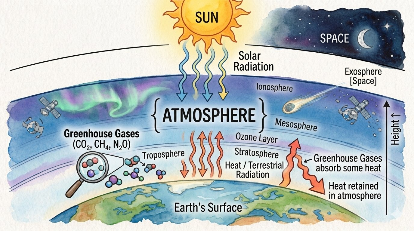
- These gases absorb outgoing terrestrial radiation and cause additional warming.
3. Greenhouse Effect
The greenhouse effect is the natural process by which certain gases in the atmosphere absorb and re-radiate outgoing heat, thereby keeping the Earth’s surface warm enough to support life.
Major Greenhouse Gases
- Water vapour
- Carbon dioxide (CO₂)
- Methane (CH₄)
- Nitrous oxide (N₂O)
- Ozone (O₃)
- Some human-made gases such as CFCs
Working of the Greenhouse Effect
4. Normal Lapse Rate of Temperature
In the troposphere, temperature generally decreases as altitude increases.
The average rate of decrease is approximately:
1°C for every 165 m of ascent
or
about 6.4–6.5°C per 1 km
This is known as the Normal Lapse Rate.
Example
Mountain regions are generally cooler than nearby lowlands because temperature decreases with increasing altitude.
5. Inversion of Temperature
Normally, temperature decreases with height. However, under certain atmospheric conditions, temperature increases with height instead of decreasing.
This phenomenon is called Temperature Inversion.
Conditions Favouring Temperature Inversion
- Long and clear nights
- Clear sky
- Calm or stable weather
- Dry air
- Snow or ice-covered surfaces
- Cold air drainage from higher slopes into valleys
6. Isotherms
An isotherm is an imaginary line joining places having equal temperature.
Isotherms are used to show the horizontal distribution of temperature over the Earth’s surface.
Features
- They connect places with the same temperature.
- They are commonly drawn on weather and climate maps.
- Their general pattern is influenced by latitude, land and sea, ocean currents and other factors.
- They often run approximately parallel to lines of latitude, but they may bend because of variations in land, sea and ocean currents.
7. Range of Temperature
The range of temperature means the difference between the highest and lowest temperatures recorded during a particular period.
There are two important types:
(a) Daily Range of Temperature
The daily range is the difference between the maximum and minimum temperature of a particular day.
Formula
Daily Range = Maximum Temperature − Minimum Temperature
Example
If:
- Maximum temperature = 35°C
- Minimum temperature = 20°C
Then:
Daily range = 35°C − 20°C = 15°C
(b) Annual Range of Temperature
The annual range is the difference between the mean temperature of the warmest month and the mean temperature of the coldest month.
Formula
Annual Range = Mean temperature of warmest month − Mean temperature of coldest month
Example
If:
- Warmest month = 45°C
- Coldest month = 20°C
Then:
Annual range = 45°C − 20°C = 25°C
8. Insolation
Insolation means Incoming Solar Radiation received by the Earth from the Sun.
It is the solar energy received by the Earth’s surface and atmosphere.
The amount of insolation is not uniform over the Earth. It varies according to several factors.
9. Factors Influencing Insolation
1. Inclination of the Sun’s Rays
The angle at which solar rays strike the Earth’s surface greatly affects the amount of energy received.
Vertical Rays
- Fall over a smaller area.
- Energy is concentrated.
- Produce greater heating per unit area.
Inclined Rays
- Spread over a larger area.
- Energy is less concentrated.
- Produce less heating per unit area.
LONG QUESTION AND ANSWER
Ans: The solar radiation travelling from the Sun and reaching the Earth’s surface is known as solar insolation (Incoming Solar Radiation). It is measured by the amount of solar energy received per square centimeter per minute.
- Inclination of the Sun’s Rays: The inclination of the Sun’s rays affects solar insolation. Vertical rays heat a smaller area than inclined (slanted) rays, so the heat energy provided per unit area by vertical rays is much more. Due to the spherical shape of the Earth, the inclination of the Sun’s rays varies by location. The insolation per unit area is maximum at the equator and minimum at the poles. It is estimated that rays inclined at 30° provide nearly half the insolation compared to those falling vertically.
- Length of the Day / Duration of Sunshine: The fact that the Earth’s axis makes an angle of \(66\frac{1}{2}^\circ\) with the plane of its orbit around the Sun has a great influence on the amount of insolation received at different latitudes. Days are longer in summer, meaning more insolation is received. While the duration of the day remains the same (12 hours) throughout the year at the equator, high latitudes experience large seasonal variations, up to a duration of six months of continuous day or night at the poles.
- Transparency of the Atmosphere:The atmosphere is largely transparent to short-wave solar radiation. The incoming solar radiation passes through the atmosphere before striking the Earth’s surface. Within the troposphere, water vapour, ozone, and other gases absorb much of the near-infrared radiation. Very small suspended particles in the troposphere scatter the visible spectrum both to space and towards the Earth’s surface. This scattering process adds color to the sky (the blue color of the day sky and the red color of the rising/setting sun).
Ans: Temperature is the thermal measurement of how hot or cold a thing or place is, measured in degrees Celsius or Fahrenheit. While heat represents the molecular movement of particles comprising a substance, temperature is the measurement of that energy created through the interaction of insolation with the atmosphere and the Earth’s surface.
- Latitude or Distance from the Equator: The Sun’s rays are almost vertical at the equator throughout the year. As a result, a large quantity of insolation is received there, and the temperature remains high (nearly 30°C). The inclination of the Sun’s rays increases as we move from the equator towards the poles, reducing the insolation intensity drastically. Consequently, temperature falls away from the equator towards the poles.
- Altitude or Height Above Sea Level: There is a gradual fall in temperature with an increase in altitude. On average, the temperature decreases at the rate of 1°C for every 165 meters (or 6.4°C for 1 km). This is known as the normal lapse rate, which is why mountains are cooler than plains.
- Distance from the Sea: Landmasses heat up and cool down more rapidly and to a greater degree than water bodies. Hence, the temperature of the air resting over land differs markedly from that over water at the same latitude. Greater extremes of temperature are felt over land than over oceans. For example, the temperature of Mumbai is more uniform than that of Delhi because Mumbai is located on the sea coast.
- Prevailing Winds: Hot winds raise the temperature while cold winds cause a fall in temperature. For instance, the Sirocco is a very hot and dry wind blowing from the Sahara desert towards Italy that raises temperatures. Similarly, a hot wind known as the “Loo” blows over a large part of North India in summer and often raises the temperature to 45°C.
- Ocean Currents: Ocean currents considerably influence the temperature of adjacent coastal land areas. Warm currents raise the temperature of coastal areas, whereas cold currents lower them.
- Nature of the Land Surface: Arid or sandy areas and black soils absorb much of the solar radiation, which helps in raising the local temperature. On the other hand, areas covered with snow or thick forests reflect a large part of the incoming solar radiation, keeping temperatures low.
- Other Factors: Aspects of slope, cloud cover, and rainfall are additional factors that control the temperature of various places.
Multiple Choice Questions (M.C.Q.s)
- a) The equator
- b) 23.5° South
- c) 23.5° North
- d) 46.5° North
- Ans: c) 23.5° North
- a) Thiruvananthapuram
- b) Chandigarh
- c) Hyderabad
- d) Nagpur
- Ans: b) Chandigarh
- a) Short-wave solar radiations
- b) Long-wave terrestrial radiation
- c) Reflected solar radiations
- d) Scattered solar radiations
- Ans: b) Long-wave terrestrial radiation
- a) Subtropical areas tend to have less cloud cover than equatorial areas.
- b) Subtropical areas have longer day hours in the summer than the equatorial areas.
- c) Subtropical areas have an enhanced greenhouse effect compared to equatorial areas.
- d) Subtropical areas are never closer to oceanic locations than equatorial areas.
- Ans: a) Subtropical areas tend to have less cloud cover than equatorial areas.
- a) Insolation: The incoming solar radiation.
- b) Albedo: The percentage of visible light reflected by an object.
- c) Isotherm: The lines joining the places of equal temperature.
- d) Annual Range: The difference between the mean temperature of the warmest and the coldest month.