CHAPTER 4
DISTRIBUTION OF CONTINENTS & OCEANS
Distribution of Continents and Oceans
The Earth’s surface is divided into two major parts—continents and oceans. About 29% of the Earth’s surface is covered by land, known as continents, while the remaining 71% is covered by water, known as oceans. The present arrangement of continents and oceans has changed over millions of years due to the movement of the Earth’s crust. To explain this distribution, several theories have been proposed, the most important being the Continental Drift Theory and the Plate Tectonics Theory.
Continental Drift Theory
The Continental Drift Theory was proposed by the German meteorologist Alfred Wegener in 1912. According to this theory, all the continents were once joined together to form a single giant landmass called Pangaea, meaning “All Earth.” This supercontinent was surrounded by a vast ocean known as Panthalassa, meaning “All Water.”
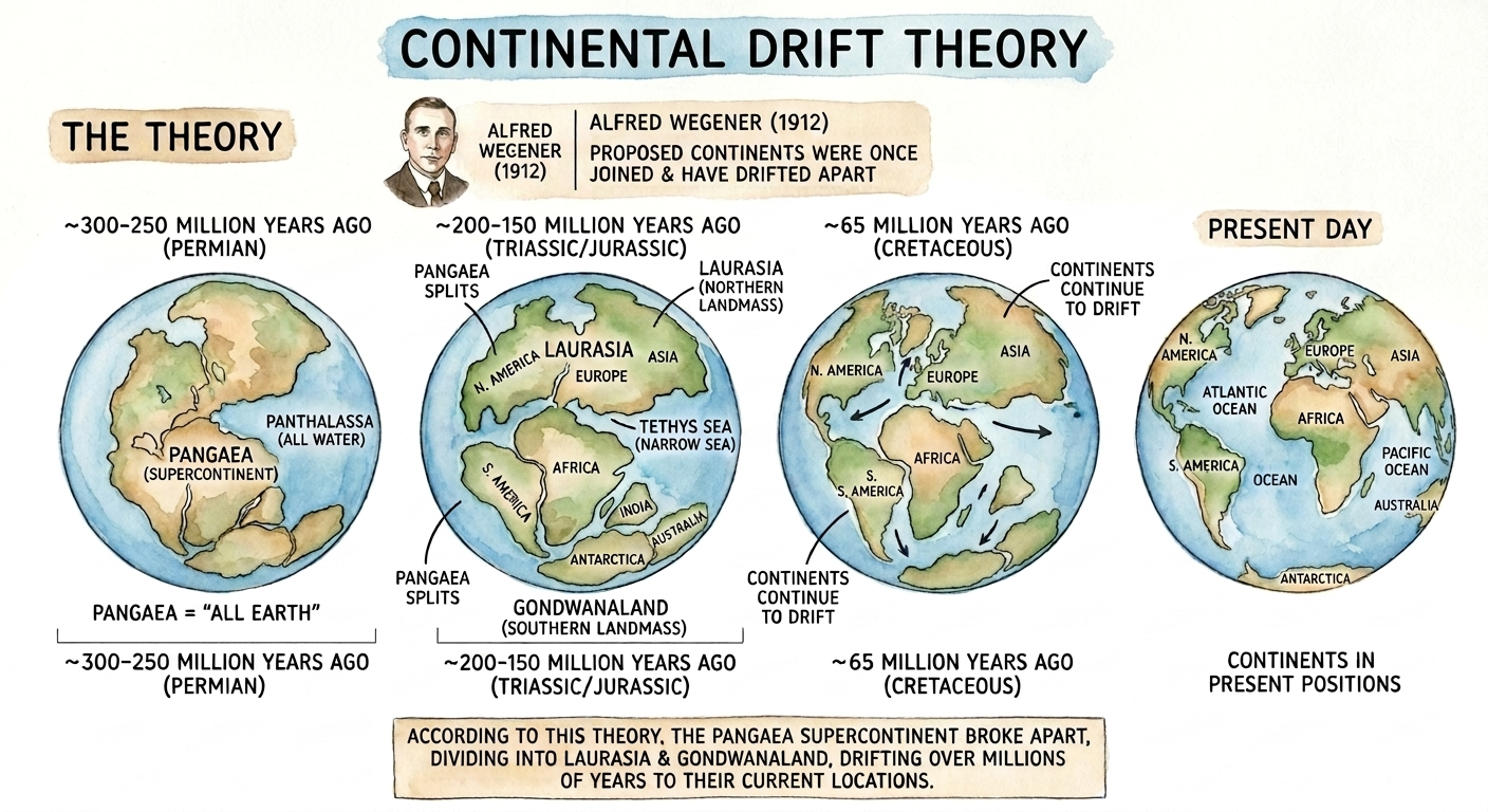
Around 250–300 million years ago, Pangaea began to break apart due to forces acting within the Earth. It first divided into two large landmasses:
- Laurasia – the northern landmass consisting of North America, Europe and Asia.
- Gondwanaland – the southern landmass consisting of South America, Africa, India, Australia and Antarctica.
These two landmasses were separated by a narrow sea called the Tethys Sea. Over millions of years, the continents continued drifting until they reached their present positions.
Evidence Supporting Continental Drift Theory
Wegener supported his theory with several pieces of scientific evidence.
1. Jigsaw Fit
The eastern coastline of South America fits closely with the western coastline of Africa, just like pieces of a jigsaw puzzle. Similar matching coastlines are also found between North America and Europe.
2. Fossil Evidence
Identical fossils of ancient plants and animals such as Glossopteris, Mesosaurus, and Lystrosaurus have been discovered on continents that are now separated by oceans. This suggests that these continents were once connected.
3. Coral Distribution
Ancient coral reefs have been found in areas that are now far from the tropical regions where corals normally grow. This indicates that the continents have shifted their positions over geological time.
4. Palaeoclimatic Evidence
Similar glacial deposits (tillites) of the Permo-Carboniferous age are found in South America, Africa, India, Australia and Antarctica. These regions must have once been joined and experienced the same climatic conditions.
5. Polar Wandering
Studies of the magnetic properties of rocks show that the Earth’s magnetic poles have changed their positions over time. This provides evidence that the continents have moved from their original locations.
Plate Tectonics Theory
The Plate Tectonics Theory was developed in 1967 by McKenzie, Parker and W. J. Morgan. It is the most widely accepted theory explaining the movement of continents and the formation of oceans, mountains, earthquakes and volcanoes.
According to this theory, the Earth’s outer rigid layer, called the lithosphere, is divided into several large and small tectonic plates. These plates float over a semi-molten layer of the mantle known as the asthenosphere. Due to convection currents within the mantle, the plates move continuously at a speed of about 5–10 cm per year.
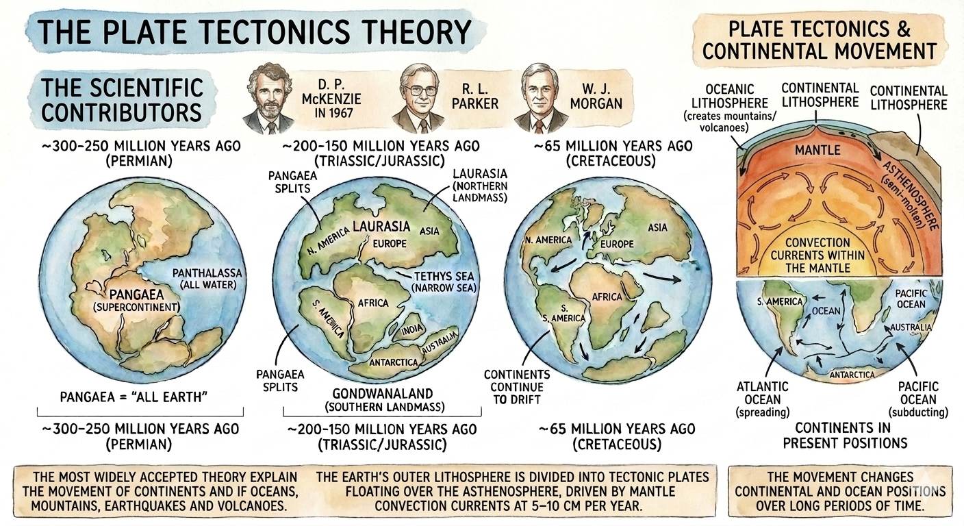
The movement of these plates changes the positions of continents and oceans over long periods of time.
Lithospheric Plates
A plate is a large, rigid slab of the Earth’s crust and the uppermost mantle. The lithosphere is divided into several major plates that move independently over the asthenosphere.
Major Plates of the Earth
- Eurasian Plate
- African Plate
- Pacific Plate
- American Plate
- Indo-Australian Plate
- Antarctic Plate
These plates constantly move, resulting in various geological activities.
Types of Plate Boundaries
The interaction between tectonic plates occurs at their boundaries. There are three main types of plate boundaries.
1. Divergent Boundary
At a divergent boundary, two plates move away from each other. Magma rises from the mantle, cools and forms new crust. This process is called sea-floor spreading.
2. Convergent Boundary
At a convergent boundary, two plates move towards each other. One plate may sink beneath the other in a process known as subduction, leading to the formation of mountains, deep ocean trenches and volcanoes.
Importance of Plate Tectonics
The Plate Tectonics Theory explains many geological phenomena, such as:
- Formation of continents and oceans.
- Movement of continents.
- Formation of mountain ranges.
- Occurrence of earthquakes.
- Formation of volcanoes.
- Sea-floor spreading.
- Creation and destruction of the Earth’s crust.
Questions & Answers
- Continents: Approximately 29% of the Earth’s surface consists of dry landmasses, which are known as continents.
- Oceans: Approximately 71% of the Earth’s surface is covered by water, which is known as oceans.
- Pangaea: Wegener assumed that during the Upper Carboniferous age, all the Earth’s landmasses were united into a single, vast supercontinent called Pangaea (which means “All Earth”) .
- Panthalassa: This mega-continent was entirely surrounded by a huge, unified world ocean known as Panthalassa (which means “All Water”)
- Eurasian Plate
- African Plate
- Pacific Plate
- American Plate
- Indo-Australian Plate
- Antarctic Plate
- Jigsaw Fit (Matching Constlines): The eastern and western coastlines of the Atlantic Ocean show a remarkable and unmistakable interlocking match
. - Fossil Evidence: Identical fossils of the plant Glossopteris and ancient animals like Mesosaurus and Lystrosaurus have been discovered in Carboniferous rocks across separated lands like India, Australia, South Africa, South America, and Antarctica
. - Coral Distribution: The geological occurrence of ancient coral reefs far away from modern tropical zones (found around 30 degree North and 30 degree South latitudes) proves that these continents were once situated much closer to the equator
. - Palaeoclimatic Unity: This involves studying past geological climates
. Matching thick glacial deposits (tillites) from the Permo-Carboniferous age are exposed across completely separate regions, including Uruguay and Brazil (South America), Africa, Southern India, Southern Australia, and Antarctica. - Polar Wandering: Permanent rock paleomagnetism reveals that the Earth’s magnetic poles have periodically changed positions over time
. This polar wandering path gives strong evidence that the continents were once united as Pangaea and have frequently shifted positions and directions
- Plates move relative to each other at typical rates of 5 to 10 cm per year
. - As they move, they interact along their margins by colliding, separating, or sliding past one another
.
- Divergent Boundaries: Where plates pull apart from each other
. - Convergent Boundaries: Where plates collide or subduct beneath one another
. - Transform Boundaries: Where plates horizontally slip and slide past each other.
Multiple Choice Question
- a) Alfred Wegener
- b) Abraham Ortelius
(Correct Answer) - c) Antonio Snider
- d) Edmond Hess
- a) Africa
- b) Antarctica
- c) Eurasia
- d) Arabian
(Correct Answer – It is a minor/micro plate)
- a) It had Laurasia in the northern part and Gondwana land in the southern part
- b) It was a big landmass consisting of all continents
. - c) It had a shallow sea known as the Tethys Sea
. - d) It was surrounded by the Pacific Ocean.
(Correct Answer – It was surrounded by Panthalassa)
- a) Revolution of the Earth
- b) Gravitation
- c) Tides
- d) Rotation of the Earth
(Correct Answer)
- a) Atlantic Ocean
(Correct Answer – Between South America and Africa) - b) Indian Ocean
- c) Pacific Ocean
- d) Arctic Ocean
- a) Nazca
- b) Philippine
- c) Arabian
- d) Antarctica
(Correct Answer – Antarctica is a major plate)
- a) 1912
(Correct Answer) - b) 1910
- c) 1918
- d) 1924