CHAPTER 10
ATMOSPHERIC CIRCULATION & WEATHER SYSTEM
Atmospheric Pressure
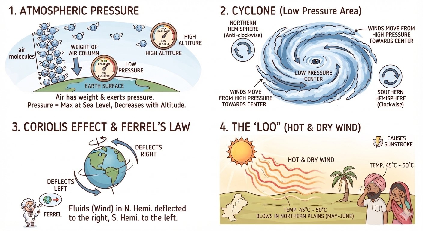
Air, like other forms of matter, has weight. Due to its weight, the atmosphere exerts pressure on the surface of the Earth. This pressure is known as atmospheric pressure. It is measured with the help of a barometer. Under normal conditions, atmospheric pressure is highest at sea level and decreases with increasing altitude. Atmospheric pressure plays an important role in producing changes in weather and determining the movement of winds.
Cyclone
A cyclone is a low-pressure area surrounded by high-pressure areas. It is generally circular or elliptical in shape. Winds move from the surrounding high-pressure areas towards the central low-pressure area. Due to the rotation of the Earth, the direction of these winds differs in the two hemispheres. In the Northern Hemisphere, winds move in an anti-clockwise direction, while in the Southern Hemisphere, they move in a clockwise direction.
Coriolis Effect and Ferrel’s Law
The rotation of the Earth on its axis affects the direction of moving winds. The force produced by the Earth’s rotation is known as the Coriolis force. According to Ferrel’s Law, moving air or any other fluid is deflected towards the right in the Northern Hemisphere and towards the left in the Southern Hemisphere. This deflection is known as the Coriolis effect and is caused by the rotation of the Earth.
Loo
The Loo is a very hot and dry local wind that blows over the northern plains of India and Pakistan. It generally occurs during May and June, particularly in the afternoon. Its temperature may reach about 45°C to 50°C. Exposure to the Loo can cause heat-related illness and sunstroke. It develops mainly because of the intense and unequal heating of the land surface.
Local Winds
Local winds are winds that develop over relatively small areas because of differences in temperature and pressure. Land and sea breezes and mountain and valley breezes are important examples.
Land and Sea Breezes
Land and sea breezes mainly influence a narrow coastal region of about 20–30 km.
During the day, land heats up faster than the adjoining sea. The air over the land becomes warm and rises, producing low pressure over the land. The sea remains comparatively cool and has relatively higher pressure. Therefore, cool air moves from the sea towards the land. This is called a sea breeze.
During the night, land cools faster than the sea. A relatively high-pressure area develops over the land, while the sea remains comparatively warmer and has lower pressure. Air therefore moves from the land towards the sea. This is called a land breeze.
Sea Breeze: Day → Sea → Land
Land Breeze: Night → Land → Sea
Mountain and Valley Breezes
Mountain and valley breezes are local winds found in mountainous regions.
During the day, mountain slopes are heated by the Sun. The air becomes warm and rises along the slopes from the valley. This movement of air is called a valley breeze.
At night, the mountain slopes cool rapidly. The air becomes cold and dense and flows down the slopes into the valleys. This is known as a mountain breeze.
Valley Breeze: Day → Valley → Slopes
Mountain Breeze: Night → Slopes → Valley
Foehn and Chinook
Foehn is a strong, warm, dry and often gusty wind that occurs on the leeward side of the Alps. Air rises on the windward side of the mountains and produces precipitation. When the air descends on the leeward side, it becomes warmer and drier. Foehn winds can melt snow and help create conditions favorable for grazing and the early ripening of grapes.
Chinook is another warm and dry mountain wind. It blows down the eastern slopes of the Rocky Mountains in the USA and Canada. The name Chinook means “snow-eater” because the wind can rapidly melt snow and clear grasslands. In spring, it may cause a sudden rise in temperature of about 15°C to 20°C within a few hours.
Horizontal Distribution of Atmospheric Pressure
The distribution of atmospheric pressure over different latitudes of the Earth is called the horizontal distribution of atmospheric pressure. The major global pressure belts are the Equatorial Low Pressure Belt, Sub-Tropical High Pressure Belts, Sub-Polar Low Pressure Belts and Polar High Pressure Belts.
Equatorial Low Pressure Belt
The Equatorial Low Pressure Belt extends approximately from 5°N to 5°S. The region receives intense heating throughout the year. As a result, air becomes warm, expands and rises, producing low pressure. This belt is also known as the Doldrums, because winds are generally weak and variable in this region.
Sub-Tropical High Pressure Belts
The Sub-Tropical High Pressure Belts occur around 30°–35° N and S. Air that rises near the Equator moves towards higher latitudes at upper levels. As it cools, it becomes denser and descends around the subtropical latitudes. This descending air produces high-pressure areas.
Sub-Polar Low Pressure Belts
The Sub-Polar Low Pressure Belts are found around 60° N and S. Here, warmer air from lower latitudes meets cold air from the polar regions. The air rises in this region, resulting in relatively low pressure.
Polar High Pressure Belts
The Polar High Pressure Belts are found near the North and South Poles. Extremely low temperatures make the air cold and dense. This dense air sinks towards the surface and creates high pressure.
Pressure-Belt Sequence
Equator → Pole
Low → High → Low → High
0° → Equatorial Low
30° → Sub-Tropical High
60° → Sub-Polar Low
90° → Polar High
Planetary Winds
Planetary winds are permanent or prevailing winds that blow over large areas of the continents and oceans throughout the year. They generally move between the major pressure belts, from areas of high pressure towards areas of low pressure. The three main types are Trade Winds, Westerlies and Polar Winds.
Trade Winds
Trade Winds blow from the Sub-Tropical High Pressure Belts towards the Equatorial Low Pressure Belt. They are steady and regular winds. In the Northern Hemisphere they are known as North-East Trade Winds, while in the Southern Hemisphere they are called South-East Trade Winds. Their direction is modified by the Coriolis force.
Westerlies
Westerlies blow from the Sub-Tropical High Pressure Belts towards the Sub-Polar Low Pressure Belts. They generally occur between about 30°–40° and 60°–65° latitudes. In the Northern Hemisphere, they generally move from the southwest towards the northeast, while in the Southern Hemisphere they move from the northwest towards the southeast.
Polar Winds
Polar Winds, also called Polar Easterlies, blow from the Polar High Pressure Belts towards the Sub-Polar Low Pressure Belts. Since they originate in the polar regions, they are extremely cold. In the Northern Hemisphere they generally blow from the northeast, while in the Southern Hemisphere they generally blow from the southeast.
SHORT QUESTION & ANSWER
Multiple Choice Questions (MCQs)
- a) 1031.25 MB
- b) 1013.25 MB
- c) 1013.52 MB
- d) 1031.52 MB
- Answer: b
- a) Near the Equator
- b) Near the Tropic of Capricorn
- c) Near the Tropic of Cancer
- d) Near the Arctic Circle
- Answer: a
- a) Chinooks
- b) Mistral
- c) Land and sea breezes
- Answer: a
- a) Clockwise
- b) Perpendicular to the isobar
- c) Anti-clockwise
- d) Parallel to the isobar
- Answer: c
- a) Calm conditions
- b) Strong winds
- c) Heavy rain
- d) Overcast skies
- Answer: a
- a) Hurricane
- b) Typhoon
- c) Willy-Willy
- Answer: b
- a) 700 MB
- b) 1200 MB
- c) 1100 MB
- d) 1300 MB
- Answer: a