CHAPTER 7
LAND FORMS & THEIR EVOLUTION
Landforms are natural features of the Earth’s surface such as valleys, waterfalls, gorges, meanders, deltas, caves and mountains. They are continuously modified by geomorphic agents such as running water, glaciers and groundwater. The major processes involved are erosion, transportation and deposition.
1. Running Water as a Geomorphic Agent
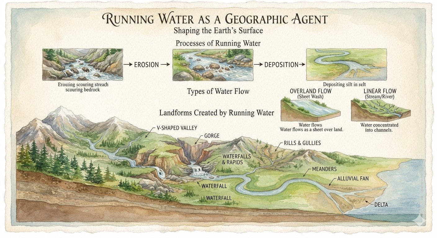
Running water or rivers are among the most important agents responsible for shaping the Earth’s surface. Water acts mainly through three processes:
Erosion → Transportation → Deposition
Types of Flow
- Overland Flow: Water flows as a sheet over the land surface.
- Linear Flow: Water becomes concentrated into channels and flows as streams and rivers.
Running water produces many landforms, including:
- V-shaped valleys
- Gorges and canyons
- Waterfalls and rapids
- Meanders
- Alluvial fans
- Deltas
- Rills and gullies
2. Waterfalls and Rapids
Waterfall
A waterfall is a steep or nearly vertical fall of river water from a considerable height.
Waterfalls commonly develop where hard and soft rocks occur together. Softer rocks are eroded more rapidly, while harder rocks resist erosion, creating a sudden vertical drop.
Types
- Permanent waterfalls
- Temporary waterfalls
Rapids
Rapids are stretches of a river where water flows rapidly over a steep, uneven or rocky river bed. Hard rocks may resist erosion and create irregular steps in the river channel.
Example: The Nile River has several important rapids.
Difference
Waterfall: Water drops almost vertically from a height.
Rapids: Water flows rapidly down a steep and irregular river bed.
3. V-Shaped Valley
A V-shaped valley is mainly formed by river erosion during the youthful stage of a river.
The river cuts deeply into its bed through vertical erosion, while weathering and mass movement widen the valley sides. The resulting valley has a narrow floor and steep sides resembling the letter V.
Main agent: Running water
Main process: Vertical erosion
4. Gorge
A gorge is a deep, narrow valley with very steep or nearly vertical sides.
It develops when a river cuts rapidly downward through resistant rocks, especially in mountainous areas. Himalayan rivers such as the Satluj, Indus and Brahmaputra have formed deep gorges.
5. Alluvial Fan
An alluvial fan is a fan-shaped deposit of gravel, sand, silt and other sediments.
It forms when a fast-flowing stream comes out of a steep mountain valley onto a flat plain. The sudden decrease in slope reduces the river’s velocity, causing it to deposit its load in a fan-like shape.
6. Delta
A delta is a depositional landform formed at the mouth of a river, where the river enters a sea, ocean or lake.
When the river enters relatively still water, its velocity decreases and it deposits silt, sand and clay. Continuous deposition produces a fertile triangular or fan-shaped plain with several distributary channels.
7. U-Shaped Valley
A U-shaped valley is formed mainly by glacial erosion.
A glacier moves through an existing river valley and deepens, widens and straightens it through processes such as abrasion and plucking. The narrow V-shaped valley is transformed into a broad valley with steep sides and a relatively flat floor.
8. Hanging Valley
A hanging valley is a tributary glacial valley that is left high above the floor of the main glacial valley.
The main glacier erodes its valley more deeply than the smaller tributary glacier. After the ice melts, the tributary valley appears to hang above the main valley. Streams flowing from it may form waterfalls.
9. Groundwater and Karst Topography
Groundwater is particularly important as a geomorphic agent in regions made of limestone.
Groundwater moves slowly, so its mechanical erosion is weak. However, rainwater absorbs carbon dioxide and becomes mildly acidic. It can then dissolve limestone through chemical solution.
The distinctive landscape formed by groundwater action in limestone regions is called Karst Topography.
Main Features of Karst Topography
Erosional features:
- Lapies
- Sinkholes
- Caves and caverns
- Natural bridges
Depositional features:
- Stalactites
- Stalagmites
- Cavern pillars/columns
10. Lapies
Lapies are irregular limestone surfaces containing deep grooves, furrows and sharp ridges.
Rainwater enters cracks and joints in limestone and dissolves the rock. Continued solution widens the cracks and produces a rough, uneven surface.
11. Sinkholes
A sinkhole is a funnel-shaped depression found in limestone regions.
It develops when groundwater dissolves limestone along joints or when the roof of an underground cavity collapses.
12. Caves and Caverns
Groundwater gradually dissolves limestone below the surface, producing underground openings called caves. Very large underground cave systems are known as caverns.
SHORT QUESTIONS & ANSWERS
- Waterfall: A waterfall occurs when river water falls down almost vertically from a significant height during its course. It is formed when softer rock layers are eroded consistently and rapidly, lowering the river bed at that specific location. When hard rocks are positioned upstream or above these softer rock layers, the differential erosion forms a vertical drop, creating a waterfall. Waterfalls are generally categorized into two types:
- Permanent waterfalls
- Temporary waterfalls
- Rapids: Rapids are formed when a chunk of hard rock runs across the bed of a river, causing the water to flow down a sudden steep gradient. Rapids occur at places where the hard valley bottom offers greater resistance to river erosion. This increases the river’s velocity as the slope becomes steep and irregular. For example, the Nile River in Africa forms several notable rapids.
A delta is a depositional landform created at the mouth of a river where it leaves its valley and enters a slow-moving or stagnant body of water, such as an ocean, sea, or lake. As the river’s velocity drops, it deposits its accumulated load of sediments (silt, sand, and clay). Deltas are highly fertile plains characterized by a network of distributary channels.
An alluvial fan is a triangle-shaped deposit of gravel, sand, and finer sediments like silt. This accumulated sediment is known as alluvium. Alluvial fans are typically created when fast-flowing streams or rivers emerge from steep mountains, hills, or canyon walls onto a flatter plain or foothill. As the slope breaks and becomes gentler, the river’s velocity drops abruptly, and its heavy load of sediment can no longer be carried forward. Consequently, the materials spread out near the base of the hill in a triangular shape that resembles a manual hand fan.
- U-Shaped Valley: Formed primarily by glacial erosion, a mountain glacier does not dig a completely new valley but instead deepens, widens, and straightens a pre-existing river valley. By grinding away structural irregularities along the valley walls and floor through plucking and abrasion, the glacier transforms a narrow V-shaped valley into a broad, steep-sided, flat-bottomed valley that resembles the letter “U”.
- V-Shaped Valley: Most of the world’s rivers form V-shaped valleys during their youthful stage. These valleys typically develop in mountainous areas with sufficient rainfall where the rocks are susceptible to vertical erosion. The continuous down-cutting action of the river, combined with the weathering and slumping of the valley walls, shapes a narrow valley resembling the letter “V”.
Like rivers, a primary main glacier erodes its valley much faster and deeper than its smaller tributary glaciers. This differential erosion creates a sharp vertical drop at the confluence where the tributary valley meets the main glacial trough. When the ice melts away, the tributary valley is left suspended high above the floor of the main valley. Streams flowing out of these tributary valleys typically plummet into the main valley below as waterfalls. These elevated glacial channels are called hanging valleys.
A gorge is a narrow, deep valley with nearly vertical, steep rocky walls. In highland or mountainous areas where a river passes through resistant beds of hard rock, the predominant geomorphic action of the river is vertical down-cutting rather than lateral erosion. This intense downward incision results in a deep, narrow canyon-like structure. Major Himalayan rivers such as the Satluj, the Indus, and the Brahmaputra have carved spectacular, deep gorges through the Himalayan ranges.
- Stalactite: When groundwater containing dissolved calcium carbonate (limestone solution) seeps through the ceiling of an underground limestone cave, it hangs in the form of drops. As the water evaporates, it leaves behind a tiny deposit of solid limestone. Over time, continuous dripping forms an icicle-shaped structure that grows downwards from the roof towards the cave floor, thinning out at its tip.
- Stalagmite: The remaining portion of the water drop that does not evaporate on the ceiling falls onto the cave floor directly below. When this water evaporates on the ground, it leaves another small deposit of limestone. This deposit builds up over time, growing thicker, flatter, and rising upwards from the floor.
Running water is widely considered the most dominant geomorphic agent responsible for degrading and reshaping the Earth’s land surface. It operates across two primary configurations:
- Overland Flow: Runoff moving across the general land surface as a broad sheet of water.
- Linear Flow: Concentrated water flowing through defined channels, such as streams and rivers within valleys.
- V-shaped valleys, Gorges, and Canyons
- Rills and Gullies
- Waterfalls and Rapids
- Meanders
- Alluvial Fans and Deltas
- Lapies: When surface rainwater absorbs carbon dioxide, it becomes mildly acidic. As this water enters the vertical cracks and joints of a limestone surface, it chemically dissolves and widens them. Over time, it forms a highly irregular surface of narrow ridges and long furrows with steep walls, known as lapies.
- Sinkholes: These are funnel-shaped depressions common in limestone regions. They form on the surface either through the gradual chemical dissolution of limestone along joints or via the structural collapse of underground cave roofs. They range from three to nine meters in average depth.
- Caves and Caverns: In regions where an insoluble rock layer sits above a soluble limestone layer, groundwater percolates below and dissolves the limestone. While the upper insoluble rock remains intact as a roof, the empty space hollowed out below forms an underground cave. Exceptionally large underground cave systems are called caverns.
- Natural Bridge: When parts of the roof of a large cavern collapse due to gravity and erosion, an uncollapsed, intact section may remain standing across the gap, forming a natural stone bridge.
- Stalactite: A mineral structure growing downward from the cave roof, formed by mineral precipitation from dripping water.
- Stalagmite: A broader mineral structure growing upward from the cave floor, formed by water drops landing directly below a stalactite.
- Cavern Pillar / Column: Over long periods, a downward-growing stalactite and an upward-rising stalagmite may eventually meet and fuse together, forming a continuous pillar from the floor to the roof.
MULTIPLE CHOICE QUESTIONS (M.C.Q.)
- Youth Stage
- Late Mature Stage
- Early Mature Stage
- Old Stage
- Correct Answer:
1. Youth Stage
- Gorge
- Alluvial Fan
- Flood Plain
- Delta
- Correct Answer:
1. Gorge
- Sinkhole
- Stalactite
- Stalagmite
- Both 2 and 3
- Correct Answer:
4. Both 2 and 3(Note: While your sheet specifically highlights Stalactite as the answer, both stalactites and stalagmites are classic depositional features of groundwater).
- Waterfall
- Cirque
- Stalactite
- Lapies
- Correct Answer:
2. Cirque
- U-shaped valley
- Gorge
- Blind valley
- Canyon
- Correct Answer:
4. Canyon
- River
- Groundwater
- Glacier
- Wind
- Correct Answer:
4. Wind
- Sea waves & Wind
- River & Wind
- River & Sea waves
- Glacier & Groundwater
- Correct Answer:
1. Sea waves & Wind